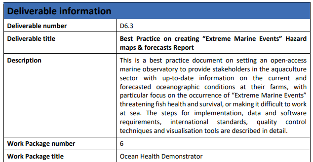
Description
An Observational and Warning System for the Aquaculture Sector: The development of a best practice to create a web portal with data products (e.g. hazard maps and forecasts) related to Extreme Marine Events.
Impact During the Project
Standardization of Methods:
Traditional State: To date, there have been relatively few developed downstream products and services that are documented in a best practice to reproduce in different sites and locations.
Advancement: A peer-reviewed published best practice report that can be adopted by different organizations, ensuring consistency in hazards maps, & forecasts and visualization.
Enhanced Credibility and Trust:
Traditional State: Without a standardized approach, results are more prone to ambiguity and guesswork with no guarantee of quality.
Advancement: Developing a “”Best Practice”” enable the users to have more clarity on how the data products were developed and produced ensuring transparency and honesty for all parties involved. It is only through the co-development approach taken in EuroSea using an iterative input from the users, that we could ensure the bespoke downstream applications developed were suitable to the customer requirements.
Collaborative Efforts and Shared Learning:
Traditional State: Fragmented development of methodologies without consideration of the end user needs.
Advancement: EuroSea activities promoted collaborative learning between industry, scientists and the aquaculture sector. As best practices are shared and uploaded to platforms like OBPS, there’s an opportunity for organizations to learn from each other, refining their methods based on collective experience.
Impact Post Project
Wider Adoption of Best Practices:
Traditional State: There is a severe lack of available open access “Best Practices“ to develop an online “Observational and Warning System for the Aquaculture Sector”.
Advancement: The measure of success post project can be monitored based on the number of downloads of the published “Best practice”, access to/interaction with the associated GitHub repository, etc. As the “Best Practice” becomes demonstrated and validated by multiple organizations, it gains credibility. This is likely to encourage more organizations to adopt the standardized approach, leading to a widespread positive change in how “extreme marine events” are forecasted. The number of people who develop a similar system would also be an appropriate metric.
Improved Preparedness and Response to Marine Events:
Traditional State: Based on user engagement exercises there is a major lack of early warning system ocean observing infrastructure for the Aquaculture.
Advancement: An open access best practice that can support groups to develop an early warning system. This can lead to better decision-making and resource allocation during “extreme marine events”, to help minimize damage and production loss (e.g. fish).
Expansion to Other Domains:
Traditional State: While there is a need by multiple disciplines (e.g. environmental assessments, biotoxin monitoring) for a similar marine observatory, the knowledge and resources needed to set-up a warning system are unavailable in many regions globally.
Advancement: Once the uptake of the “Best Practice” increases, we would expect an increased number of developed online marine observatories.
Advancement over and above State of the Art
The development of a best practice report for “Extreme Marine Events” hazard mapping and forecasting represents a pivotal move towards standardizing marine hazard predictions. It not only ensures consistency and enhances trust in the forecasts but also fosters a culture of shared learning and collaboration among marine organizations. In the long run, such efforts can lead to better preparedness, more efficient resource allocation during emergencies, and potentially, the saving of lives and assets.
Links and References
Link to D2.4 – Indicators for demonstrators and forecast: https://eurosea.eu/download/eurosea_d2-4_development_targeted_indicators-2/?wpdmdl=5518&refresh=650197c521a2e1694603205
Link to D6.3 – Best Practice on creating “Extreme Marine Events” Hazard maps & forecasts Report: https://eurosea.eu/download/eurosea_d6-3_bp_extreme_marine_events_hazard_maps__forecasts_report/?wpdmdl=5591&refresh=650197cb50af71694603211
