Climate change predictions
Development of appropriate indicators to monitor and forecast in support of SDG14 (Sustainable Development Goal 14: Life Below Water)
This initiative revolves around the creation and refinement of ocean and climate indicators that can better support the objectives of the Sustainable Development Goal 14 (SDG14) - "Life Below Water." By aligning Essential Ocean Variables (EOVs) with these indicators, the goal is to enhance monitoring capabilities and provide accurate forecasting tools related to marine vulnerabilities and risks.
Enhanced Coordination and Collaboration Among Ocean Observation Networks and Disciplines
The initiative emphasizes the necessity of fostering tighter coordination and collaboration between various networks and disciplines involved in ocean observation. This encompasses both the in-situ community, which focuses on direct measurements, and the remote communities that rely on indirect methods like satellite imaging. The ultimate aim is to ensure a more seamless and integrated ocean observing system.
Implementation of Novel Multi-Parametric Monitoring Stations – Augmented Observatories
The term "augmented observatories" implies an enhancement or expansion of traditional observatory functions. In this case, the implementation of novel multi-parametric monitoring stations suggests a strategic deployment of advanced monitoring facilities that are capable of measuring multiple parameters simultaneously, offering a holistic and integrated view of the observed domain.
Deployment of Enhanced Argo Floats for Oceanic Measurements
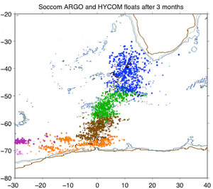
This initiative involves the deployment of advanced Argo floats in strategic marine locations, equipped with an array of sophisticated sensors. The 5 DEEP Argo floats in the Irminger Sea come with Oxygen sensors, and the 5 BGC Argo floats in the tropical Atlantic are fitted with sensors to measure dissolved oxygen, pH, chlorophyll-a, downwelling irradiance, backscatter, and the CTD head.
Deployment of 2 In-situ Buoys with Advanced Monitoring Capabilities
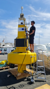
The introduction of two in-situ buoys equipped to measure temperature/salinity (T/S), dissolved oxygen (DO), pH, and currents represents a significant enhancement in marine monitoring infrastructure. Additionally, these buoys come with the capability to provide real-time and near-time predictions.
Enhanced Design of Multi-Platform Experiments
This initiative focuses on refining the design of multi-platform experiments by integrating a myriad of in-situ observation tools, like CTD, ADCP, gliders, uCTD, drifters, and more, with advanced remote sensing technologies, such as nadir altimetry and wide-swath altimetry from SWOT. The integration is further optimized through Observing System Simulation Experiments (OSSEs), ensuring that the observational setups are maximally effective and efficient.
Improvement of GO-SHIP Europe
The enhancement of the GO-SHIP (Global Ocean Ship-based Hydrographic Investigations Program) Europe initiative signifies a vital step in the evolution of oceanographic observations. This initiative focuses on refining and expanding the existing GO-SHIP Europe framework, potentially through an increased number of Essential Ocean Variables (EOVs) or additional transects.
Low Maintenance Multiparameter Novel Tide Gauges
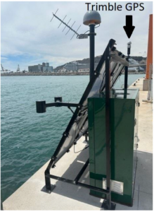
The deployment of these innovative tide gauges in cities like Barcelona, Taranto, and Alexandria represents a leap in tide observation technology. Designed for low maintenance, these tide gauges are not just instruments for measuring sea levels but are sophisticated devices capable of capturing various parameters related to tides.
Comparative Analysis of Mapping Methods for 3D Gridded Field Reconstruction
The initiative delves into evaluating the efficiency and efficacy of various mapping methods—optimal interpolation, machine learning techniques, and data assimilation—for the purpose of reconstructing simulated observations. The observations in question are sourced from several realistic numerical models like CMEMS reanalysis, WMOP, and eNATL60. The end goal is to generate 3D gridded fields that provide a comprehensive spatial understanding of the studied marine phenomena.
BioEco Workshops and Mapping Initiative
The BioEco Workshops and Mapping Initiative represents a coordinated effort to enhance the BioEco Essential Ocean Variable (EOV) observing networks across Europe. Through a series of workshops and extensive mapping exercises, stakeholders aim to identify gaps, streamline best practices, and foster connections across the BioEco observing landscape in the EU.
